|
The Wild & Scenic River System  In
1968, Congress passed the National Wild and Scenic Rivers Act to help protect
selected free-flowing rivers that have outstanding natural, cultural, and
recreational values. Congress envisioned the National Wild and Scenic Rivers
System as a cooperative effort relying on the
actions of private individuals and groups, and on all levels of government
The Ad provides communities, where rivers flow across non-federal lands,
with a river protection method that is sensitive to local needs and concerns.
Although most protected rivers are on federal lands, the number of those
flowing through non-federal lands is increasing. In 1992, the Great Egg
Harbor River became the 153rd river in the nationwide wild and scenic system,
and is the only one lying in the Embayed section of the Atlantic Coastal
Plain. In
1968, Congress passed the National Wild and Scenic Rivers Act to help protect
selected free-flowing rivers that have outstanding natural, cultural, and
recreational values. Congress envisioned the National Wild and Scenic Rivers
System as a cooperative effort relying on the
actions of private individuals and groups, and on all levels of government
The Ad provides communities, where rivers flow across non-federal lands,
with a river protection method that is sensitive to local needs and concerns.
Although most protected rivers are on federal lands, the number of those
flowing through non-federal lands is increasing. In 1992, the Great Egg
Harbor River became the 153rd river in the nationwide wild and scenic system,
and is the only one lying in the Embayed section of the Atlantic Coastal
Plain. How the river was designated In 1985, local landowners and public officials began to
focus on the future of the Great Egg Harbor River. The National Park Service
heel local work-shops to explore possible ways to protect the dyer and
its tributaries local governments passed resolutions endorsing a study
of the dyer to determine its eligibility and suitability for inclusion
in the National Wild and Scenic River System and, in 1986, President Reagan
signed the legislation authorizing this study. Five years later, the Final
Study Re-port detailed the river sections eligible for the designation,
and the resources in need of protection. This report, along with the persistent
work of the non-profit Great Egg Harbor Watershed Association, became the
cornerstone of the effort Congressman Bill Hughes introduced legislation
to have the river designated a scenic and recreational river that is part
of the national wild and scenic river system. In October 1992, President
Bush signed the bill designating 129 miles of the Great Egg a national
wild and scenic river. The Great Egg Harbor River & Watershed
Who will regulate the river? Currently, a mix of local, state, and federal
government agencies have the authority to regulate the river. The designation
of the river into the national system did not change those authorities
Local zoning and planning laws and the state's Pinelands and
Coastal Areas Facilities Review Act regulations will continue to provide
the primary protection for the river and its watershed. The federal designation
is a vehicle designed to stimulate, enhance, and coordinate local river
protection efforts. To reach these ends agreements are being drawn with
each affected community along the river to develop local river management
plans. Who develops Local River Management Plans? Each of the 13 affected communities along the river is
being asked to develop its own Local River Management Plan. The National
Park Service is providing funding and technical assistance, and is funding
a local professional planner to coordinate the effort and assist each community
individually. Although each community's plan will vary somewhat due to
the different river resources and needs in each river section, every effort
will be made to standardize plans wherever possible. Collectively, the
13 individual plans will form a Comprehensive River Management Plan for
the entire river. How designation will benefit communities Communities near a nationally recognized river benefit
from the scenic, recreational, historical, and cultural qualities of their
nearby river. It is general believed that the scenic and recreational designation
increases property values; people want to own property near designated
rivers. Residents experience heightened sense of pride, and a greater willingness
to help preserve the beauty and character of the river and its watershed.
But the greatest benefit will probably be experienced by future generations:
the many river qualities we now experience and observe w be managed and
protected for many decades I come. Current status of the planning process  Early
in 1995, representatives of the 13 municipal ties began meeting regularly
with the Park Service the Watershed Association, and the planning consul
ant to finalize their river management plans. Some municipalities have
expressed an interest in promoting tourism on a limited basis, while others
prefer to discourage tourists from visiting their section of the river;
the concern is that overuse of the river will destroy the qualities they
are seeking to protect. On of the major goals of the Comprehensive Management
Plan is to clarify each municipality's concerns and goals, and to recognize
river use limitations, suitable access points, and tourism needs, such
a restaurants, lodging, and points of interest. Early
in 1995, representatives of the 13 municipal ties began meeting regularly
with the Park Service the Watershed Association, and the planning consul
ant to finalize their river management plans. Some municipalities have
expressed an interest in promoting tourism on a limited basis, while others
prefer to discourage tourists from visiting their section of the river;
the concern is that overuse of the river will destroy the qualities they
are seeking to protect. On of the major goals of the Comprehensive Management
Plan is to clarify each municipality's concerns and goals, and to recognize
river use limitations, suitable access points, and tourism needs, such
a restaurants, lodging, and points of interest.
How can I participate? If you live within the Great Egg Harbor River watershed
you can participate by learning more about the river and its nearby tributaries.
Con-tact your local government officials and ask them about your own Local
River Management Plan. If you live outside the watershed and wish to visit,
contact the information sources below to find out what communities. are
encouraging tourism. Remember that the river is being man-aged for use
by wildlife and by people; both uses are equally important. Visitors please note The river flows through land that is primarily privately
owned, therefore river access is limited. For more Information contact
This brochure was prepared by the National Park Service, Northeast Field Area 8/95 |
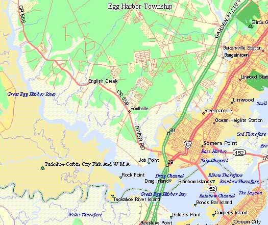
 The
Great Egg Harbor River begins in suburban towns
and meanders for 59 miles, draining 304 square miles of pristine wetlands
in the heart of New Jersey's Pinelands Reserve on its way to the Atlantic
Ocean. Dissolved iron and tannin, a product of fallen leaves and cedar
roots, produce the river's tea-colored "cedar water" along much
of its length. The freshwater and tidal wetlands serve as resting, feeding,
and breeding areas for waterfowl throughout the year amid undisturbed forests
and swamp areas. The watershed has been occupied since pre-historic times,
lived upon traditionally by the Lenape Indians before occupations by Europeans
in the early 1700s. The lands contained all the necessary materials for
shipbuilding, and in the Revolutionary War its "bog iron" made
cannon balls while its hidden coves sheltered privateers. Blast furnaces,
sawmills, glass factories, and brick and tile works followed until the
Industrial Revolution drew its people away. Today, the development of the
area's prime agricultural land has contributed greatly to the cultural
diversity of the area.